As of Tuesday morning, a large cluster of strong thunderstorms has already developed across West Texas. As a system of low atmospheric pressure progresses eastward, the storm activity will push into South-Central Texas by the second half of the day, likely making its way into the San Antonio metro area after 8 p.m.
If you plan on attending an outdoor Spurs watch party for Game 5 of the Western Conference Finals, it’ll be a good idea to leave the event before halftime or have a plan to seek shelter when storms arrive late.
A flood watch has been issued for the Hill Country and I-35 corridor, including San Antonio, the National Weather Service announced. The watch will go into effect at 4 p.m. Tuesday and last through early Wednesday morning. Between 1 and 3 inches of rainfall is likely across the watch area, with isolated totals up to 5 inches possible.
Not only will storms bring a flash flood threat, the strongest activity might also bring hail, damaging winds and frequent lightning. If you plan to watch Tuesday night’s game on TV, consider watching it from inside your home instead. Here’s an updated timeline for what you can expect.
Afternoon (Noon to 5 p.m.): For much of the day, dry weather is likely across San Antonio. Partly to even mostly sunny skies are expected at times, as temperatures rise into the mid- to upper 80s. An isolated shower or storm is possible, but overall rain chances will only be at around 20% during this time.
Evening (5 to 8 p.m.): Strong thunderstorms is expected to move through the Texas Hill Country, affecting cities such as Fredericksburg, Kerrville, Blanco and Llano. Areas to the west, such as Hondo, Uvalde,, Laredo, and Eagle Pass may also see strong storms during this time. Rain chances in San Antonio will stay low through the early evening.
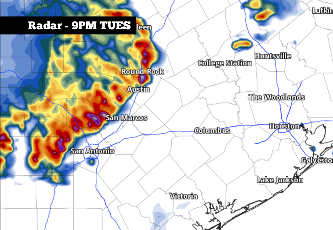
Tuesday night (8 p.m. to 1 a.m. Wednesday): Weather models indicate that thunderstorms are likely to reach western parts of Bexar County by 8 p.m. Then, they’ll likely move into downtown San Antonio by 9 p.m. Storms may continue in the area through midnight, before activity winds down overnight.
Yes, the strongest storms could be capable of producing large hail, but the risk is relatively small. San Antonio is under a level 1 of 5 risk of severe storms, according to the National Weather Service’s Storm Prediction Center. The low-end threat means that, while a few storms could produce large hail and damaging wind gusts, most will not.
The risk of hail and damaging winds will be higher to the west of San Antonio. Cities such as Kerrville, Bandera, Hondo, Uvalde, Junction and Leakey are under a level 2 of 5 risk of severe thunderstorms.
Flooding: The larger threat will be the risk of street and urban flooding, as storms may produce rainfall rates of 2 inches per hour at times. Travel on area roadways may become dangerous late Tuesday, especially after 10 p.m.
Storms will move out of the area relatively quickly, which will thankfully limit the flood threat along area rivers, creeks, and streams.
Source link ← Back to News